HULL UK
HULL
HomeGeophysicsResistividad eléctrica / SEV (sondeo vertical)

Electrical Resistivity / VES Surveys in Hull

Geotechnical engineering with regional judgment.

LEARN MORE

Hull sits on deep alluvial and glacial till deposits overlying chalk bedrock, so the ground conditions vary significantly within a few hundred metres. A standard borehole alone might miss a sand channel or a perched water table. That is where electrical resistivity and Vertical Electrical Sounding (VES) come in. These geophysical methods map resistivity contrasts in the subsurface, revealing lithological changes, the depth to the chalk, and potential groundwater pathways. Before we mobilise drilling rigs, we often run a resistivity survey to target the borehole locations more efficiently. Complementing this with a calicatas exploratorias allows direct visual confirmation of the shallow stratigraphy identified by the geophysics.

Illustrative image of Electrical resistivity / VES (Vertical Electrical Sounding) in Hull
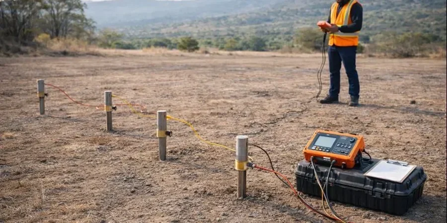
A resistivity survey in Hull often reveals buried river channels and solution features in the chalk that no borehole alone would detect.

Our service areas

Scope of work

The typical sequence in Hull consists of made ground, soft alluvial clays and silts, stiff glacial till, and then the underlying Cretaceous chalk. The resistivity values of these units differ markedly: made ground and dry till give high readings, while saturated clay produces low resistivity. A VES survey with a Schlumberger array can resolve these layers down to about 40 metres, depending on the spread length. We adhere to BS 5930 and the guidance in the CIRIA report C574 for geophysical surveying. For deeper investigations targeting the chalk aquifer, we combine VES with georradar GPR to image the top-of-chalk surface and any solution features within it. The data are inverted using 1D and 2D software to produce resistivity models that we interpret alongside existing borehole logs.
Technical reference — Hull

Area-specific notes

In the Hessle foreshore area, the alluvial clays are thick and soft, producing very low resistivity values that can mask deeper features if the survey is not designed correctly. Conversely, on the higher ground near Cottingham, the till is stiffer and drier, giving higher background resistivity. If we set the electrode spacing too small on the till, we might not see the chalk. We always calibrate against a nearby borehole before starting the main survey. Missing a solution feature in the chalk could lead to foundation instability or excessive water ingress during excavation, so the resistivity survey acts as a critical early warning tool.

Need a geotechnical assessment?

Reply within 24h.

Email: contact@geotechnical-engineering.biz

Standards used


BS 5930:2015 – Code of practice for ground investigations, CIRIA C574 – Engineering in chalk, Eurocode 7 (EN 1997-1:2004) – Geotechnical design

Technical parameters

ParameterTypical value
Array configurationSchlumberger, Wenner, dipole-dipole
Maximum depth of investigationUp to 50 m (VES) / 30 m (2D imaging)
Electrode spacing1 m to 20 m (variable per target)
Resistivity range resolvable0.1 to 10,000 ohm-m
Data inversion softwareRes2DInv, IPI2Win, custom 1D forward models
Typical field productivity8–12 VES soundings per day (crew of 2)

Common questions


How does an electrical resistivity survey differ from a borehole in Hull?

A borehole gives you a direct sample at one point, but may miss lateral variability. A resistivity survey covers a much wider area, identifying changes in soil type, groundwater, and bedrock depth between boreholes. In Hull's variable alluvial and till deposits, combining both methods provides a far more reliable ground model.

What is the typical cost of an electrical resistivity / VES survey in Hull?

The cost depends on the number of soundings, array length, and site access. As a general guideline, a VES survey with 8 to 12 soundings in the Hull area ranges from £450 to £860. Contact us for a fixed quotation based on your specific project scope.

Can resistivity surveys detect solution features in the chalk under Hull?

Yes. The chalk beneath Hull often contains solution cavities and pipes filled with soft sediment or water, which have a much lower resistivity than the surrounding intact chalk. A 2D ERT profile with 2 m electrode spacing can typically resolve features larger than 1 m in diameter, provided the survey line is positioned correctly over the target.

Location and service area

We serve projects across Hull.

Location and service area