Geophysics in Hull provides a non-intrusive means of investigating the subsurface, essential for understanding the complex Quaternary geology underlying the city and its surrounding areas. The region is characterised by thick sequences of glacial till, alluvium, and fluvioglacial deposits overlying Cretaceous Chalk bedrock, conditions that create significant variability in ground engineering properties. A robust geophysical survey is often the first critical step in a well-planned site investigation, helping to map lithological boundaries, identify buried channels, and detect potential voids or dissolution features within the chalk. All works are conducted in accordance with British Standards, principally BS 5930:2015+A1:2020 (Code of practice for ground investigations) and BS 8573:2016 (Code of practice for the use of geophysical techniques in ground investigation), ensuring data quality and legal compliance for your project.
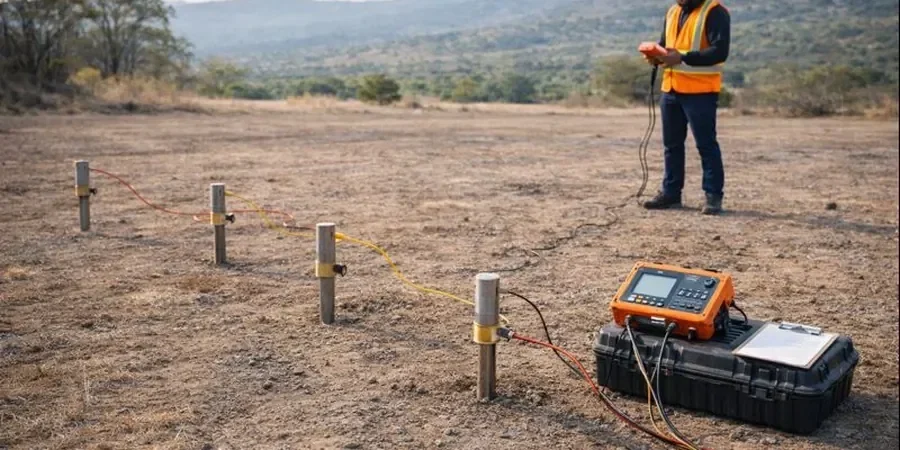
The methodologies we apply are selected specifically to match the geological challenges of the Humber region, deploying a suite of high-resolution surface and downhole techniques. Electrical Resistivity Tomography (ERT) is frequently used to delineate the interface between low-resistivity clay tills and more resistive granular deposits or chalk, a crucial input for subsequent soil mechanics study and foundation design. For rapid profiling of extensive sites, ground penetrating radar (GPR) and electromagnetic (EM) conductivity mapping offer efficient solutions, though their effectiveness is carefully assessed against the clay-rich soils prevalent in Hull. Seismic methods, including MASW (Multichannel Analysis of Surface Waves), are employed to derive stiffness profiles for correlating with SPT N-values, while downhole seismic testing provides a direct measurement of material stiffness. These approaches are integrated with targeted In-Situ to deliver a calibrated ground model that adheres to the requirements of Eurocode 7 and the UK National Annex for geotechnical design.
Typical projects across Hull and the East Riding benefit directly from this integrated approach, addressing site-specific risks on developments ranging from residential housing estates on the city’s margins to major infrastructure and flood defence schemes along the Humber Estuary. Geophysical survey is instrumental in mapping the thickness of compressible alluvial layers beneath proposed embankments and in locating abandoned mine entries or crown holes in the chalk, which pose significant collapse hazards. The data is also critical for environmental site characterisation, where it aids in tracking the migration of contaminants through variable superficial deposits. For deep basement constructions in the city centre, we combine cross-hole seismic tomography with laboratory testing on recovered cores to provide a seamless link between geophysical properties and the detailed laboratory data required for advanced numerical modelling, ensuring a rigorous soil classification is achieved across the entire site.
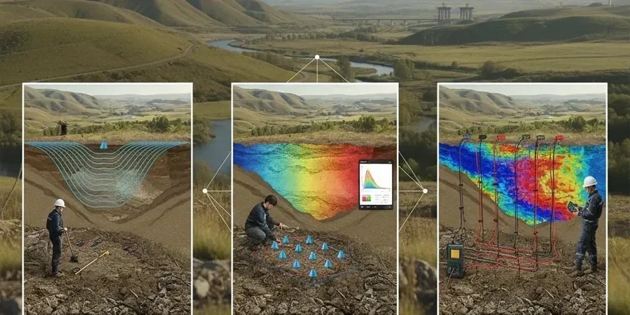
Our process begins with a desktop study and survey design tailored to your project’s specific targets and the local geological model, followed by data acquisition using calibrated equipment and meticulous quality control. The raw data undergoes advanced processing and inversion to produce 2D and 3D interpretative models. The final deliverable is a comprehensive factual report with interpretative sections, presenting geophysical cross-sections and plan maps that clearly delineate geological structures, anomalous zones, and material boundaries. This output directly informs the design of subsequent intrusive investigation points, drastically reducing the number of boreholes required and the overall project costs while significantly lowering the risk of encountering unforeseen ground conditions. The value lies in providing a spatially continuous understanding of the subsurface, transforming a fragmented set of point data into a complete and defensible ground model that underpins safe and economical design.